GeographyGeography · 7 / 26
The hydrosphere: oceans, rivers, lakes
School curriculum· 30 min· 22 questions
Learn first: The lithosphere, relief and rocks
The hydrosphere is the Earth’s water envelope: oceans, seas, rivers, lakes, glaciers, groundwater, swamps and water vapour in the air. All of these are linked by the global water cycle. Water is the source of life, a moderator of climate, a transport route and an economic resource. For a dry country like Uzbekistan, understanding and saving water is especially important. Exams ask about the parts of a river, calculations of fall, gradient and discharge, types of lakes and how water is distributed.
§1. Water reserves and the global cycle
About 96.5% of water is in the oceans; fresh water is about 2.5%, most of it (roughly two-thirds) locked in glaciers
The total volume of water on Earth is about 1.4 billion km³. River and lake water, which people use directly, is a tiny fraction of fresh water. That is why fresh water is a limited and precious resource.
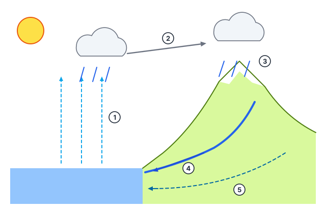
The global water cycle: driven by solar energy, water evaporates from the ocean and the land, the vapour rises, cools and forms clouds, falls as precipitation and returns to the ocean through rivers and groundwater.
- The large cycle links ocean and land;
- the small cycle takes place over the ocean only (evaporating and falling back into it);
- the inland cycle operates in basins with no outlet to the ocean (as in Central Asia).
The cycle constantly renews fresh water and carries heat from the equator to the poles.
Worked example
Earth holds about 1,386 million km³ of water, of which 2.5% is fresh. What is the volume of fresh water?
- Convert the percentage: 2.5% = 0.025.
- Volume: 1,386 · 0.025 ≈ 34.7 million km³.
- Answer: about 35 million km³, most of it in glaciers.
§2. Rivers: parts and features
A river is a permanent stream of water flowing in a channel it has cut itself. Its parts are:
- the source — where it begins (a spring, glacier, lake or swamp);
- the mouth — a delta (branching, built of sediment, e.g. the Nile, the Volga) or an estuary (funnel-shaped, entered by sea water);
- tributaries — rivers flowing into the main one;
- the river system — the main river with all its tributaries;
- the basin — the area from which the river collects water; the watershed (divide) is the boundary between neighbouring basins.
In its upper course the river is fast and cuts downwards; in the middle course the valley widens; in the lower course the water slows and deposits sediment.
Fall = height of source − height of mouth; gradient = fall / length (m per km)
Discharge = cross-sectional area · velocity (m³/s)
Mountain rivers are fast and rich in energy, so hydroelectric stations are built on them; lowland rivers are slow with wide valleys and suit navigation.
The longest river is the Nile; the river with the greatest flow and the largest basin is the Amazon
Uzbekistan’s main rivers: the Amu Darya forms where the Panj and the Vakhsh join, and the Syr Darya where the Naryn and the Kara Darya meet in the Fergana Valley; both belong to the Aral Sea basin. The Zarafshan rises from the Zarafshan Glacier and no longer reaches the Amu Darya — its water is used up for irrigation.
Worked example
A river rises at 1,200 m, its mouth is at 200 m, and it is 500 km long. Find the gradient.
- Fall: 1,200 − 200 = 1,000 m.
- Gradient: 1,000 m / 500 km = 2 m/km.
- Answer: 2 m per km.
§3. River feeding and regime
Feeding means a river’s sources of water: snow, glaciers, rain and groundwater. Most rivers have mixed feeding.
The regime is how the water level changes over a year:
- high water (spring/summer flood) — the period of highest water that recurs in the same season every year;
- flash flood — a short rise after a downpour or sudden snowmelt;
- low water — the period of lowest water.
Central Asian rivers (the Amu Darya, the Syr Darya and their tributaries) are fed mainly by snow and glaciers: snow and ice in the mountains melt in summer, so high water comes in summer — just when irrigation is most needed. Equatorial rivers are fed by rain all year and are full, while monsoon rivers fill with summer rains.
Worked example
A river’s cross-section is 200 m² and its velocity 1.5 m/s. What is the discharge?
- Formula: discharge = cross-sectional area · velocity.
- 200 · 1.5 = 300 m³/s.
- Answer: 300 m³/s.
§4. Lakes and swamps
A lake is a body of water filling a natural hollow on land and not directly joined to the ocean. By the origin of the hollow:
- tectonic — deep and elongated: Baikal (the deepest lake in the world, 1,642 m), Tanganyika;
- volcanic — in the craters of extinct volcanoes;
- glacial — in hollows left by ancient ice sheets (many lakes of North America and northern Europe);
- dammed — where a landslide blocks a river (Lake Sarez in the Pamirs);
- relict — the remains of an ancient sea (the Caspian, the largest lake in the world).
By water exchange: lakes with an outflow are fresh; lakes without an outflow are salty, because water evaporates while salts remain (the Caspian, the Aral). Balkhash is fresh in its western part and salty in its eastern part.
Swamps form where moisture is excessive and drainage is poor; peat accumulates in them. They are common in the taiga and tundra.
Artificial lakes — reservoirs (in Uzbekistan the Charvak, Tuyamuyun and others) — are built for irrigation, power and water supply.
§5. Glaciers and groundwater
Glaciers form above the snow line — the height above which snow does not melt during the year. The snow line is high at the equator and falls towards the poles.
- Ice sheets cover Antarctica and Greenland; they are the main store of fresh water.
- Mountain glaciers include the Fedchenko Glacier in the Pamirs (one of the longest mountain glaciers).
- Permafrost is ground that stays frozen all year (Siberia, northern North America).
Groundwater forms as rain and river water soak into the ground:
- ground (water-table) water lies above the first impermeable layer;
- interstratal water lies between two impermeable layers;
- artesian water is under pressure and rises from a well by itself;
- mineral and thermal (hot) springs are used for medical treatment.
§6. Seas and protecting the hydrosphere
A sea is a part of the ocean that cuts into the land or is separated by islands.
- Inland seas reach deep into a continent and are linked to the ocean by straits (the Mediterranean, Black and Baltic seas);
- marginal seas lie at the edge of a continent, partly cut off from the ocean by islands or peninsulas (the Barents Sea, the Sea of Japan);
- inter-island seas lie among islands.
The main threats to the hydrosphere are industrial and household waste water, oil spills, fertiliser run-off and over-abstraction. The tragedy of the Aral Sea, which dried up because river water was taken for irrigation, is a striking example. Water-saving (drip) irrigation and waste-water treatment are key measures.
Check yourself
- Where is most fresh water stored?
- What is a river basin?
- The deepest lake in the world?
- What type of sea is the Black Sea?
- What is groundwater under pressure called?
- Fall 600 m, length 300 km. Gradient?
- Cross-section 50 m², velocity 2 m/s. Discharge?
- In which season do Central Asian rivers have high water?
Common mistakes
- Leaving the Caspian off the list of lakes — it is the largest lake in the world.
- Thinking most fresh water is in rivers — it is in glaciers.
- Confusing fall and gradient: gradient is fall divided by length.
- Swapping the longest river and the river with the greatest flow (the Nile and the Amazon).
- Assuming lakes without an outflow are fresh — salts build up in them.
Score: 0 / 8 correct (0 attempted)