Learn first: The shape and motions of the Earth
The lithosphere is the Earth’s hard, rocky shell. Relief, mineral resources, earthquakes and volcanoes, and soil are all linked to processes in the lithosphere. It interacts constantly with the other envelopes: water and wind wear it down, organisms create soil, and relief in turn shapes climate and rivers. In this topic you need to distinguish the Earth’s internal structure, internal and external forces, types of rock and landforms.
§1. The Earth’s internal structure
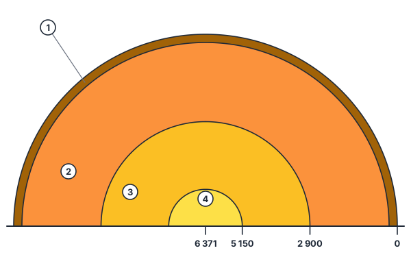
The Earth’s mean radius is about 6,371 km. Its interior cannot be seen directly; scientists study it from how earthquake waves travel at different speeds through different layers. The Earth is made of shells:
- The crust is the thinnest layer. Continental crust is 30–70 km thick (thicker under mountains) and has sedimentary, "granite" and "basalt" layers. Oceanic crust is 5–10 km thick and has no "granite" layer.
- The mantle reaches a depth of about 2,900 km and makes up most of the Earth’s volume. Its upper part contains a softer, plastic layer, the asthenosphere, over which lithospheric plates move.
- The core has an outer (liquid) and an inner (solid) part, made mainly of iron and nickel. The Earth’s magnetic field is linked to motion in the outer core.
Lithosphere = crust + the rigid upper part of the mantle
Temperature rises with depth: in the upper crust by about 3 °C per 100 m on average. This heat is used as geothermal energy.
Worked example
At the surface (at the top of a mine) it is +10 °C. What is the temperature at a depth of 1,500 m (+3 °C per 100 m)?
- Depth in hundreds of metres: 1,500 / 100 = 15.
- Rise: 15 · 3 = 45 °C.
- Temperature: 10 + 45 = 55 °C. Answer: about +55 °C.
§2. Lithospheric plates and internal forces
Early in the twentieth century A. Wegener proposed continental drift: today’s continents once formed a single supercontinent, Pangaea. Modern plate tectonics developed this idea. The lithosphere is divided into large plates (Eurasian, African, North American, South American, Pacific, Indo-Australian, Antarctic and others), which move a few centimetres a year.
- Where plates move apart, mid-ocean ridges and rift valleys form (the East African Rift).
- Where plates collide, two continental plates push up fold mountains (the Himalayas: the Indian plate pushing into Eurasia); where an oceanic plate sinks under a continental one, deep trenches and volcanoes form (the Pacific "Ring of Fire", the Andes).
- Where plates slide past each other, strong earthquakes occur.
Internal forces (endogenic processes) are tectonic movements, volcanism and earthquakes. The point inside the Earth where an earthquake starts is the hypocentre (focus); the point on the surface above it is the epicentre. Earthquake intensity is measured in points by the damage done; magnitude is measured on the Richter scale by the energy released. The mountainous part of Central Asia is seismically active; the 1966 Tashkent earthquake is a vivid example.
The parts of a volcano are the magma chamber, the vent and the crater. Magma that reaches the surface is called lava. Volcanic areas have geysers — hot springs that erupt from time to time (Iceland, Kamchatka).
Worked example
A plate moves 5 cm a year. How far does it travel in 1 million years?
- Yearly movement: 5 cm = 0.05 m.
- Total: 0.05 · 1,000,000 = 50,000 m.
- Answer: 50 km — slow, but a huge distance over geological time.
§3. Rocks and minerals
By origin there are three types of rock:
- Igneous rocks form as magma cools: granite (cooling slowly at depth, coarse-grained) and basalt (cooling quickly at the surface). Ore minerals (iron, copper, gold) are often linked to them.
- Sedimentary rocks form as weathered material and organic remains build up in layers: sand, clay, limestone, coal, oil, gas, salts. They collect in the sedimentary cover of platforms and in basins.
- Metamorphic rocks are other rocks changed by high temperature and pressure: marble (from limestone), gneiss (from granite), slate (from clay).
Ore (metal) minerals — fold mountains and shields; fuels (oil, gas, coal) — sedimentary layers
Large, stable parts of the crust are platforms (beneath plains); mobile parts are fold belts (mountains). Where a platform’s ancient rocks are exposed at the surface it is called a shield.
Minerals fall into three groups: ore (metals), non-metallic (salt, phosphorite, building materials) and fuel (coal, oil, gas). Examples from Uzbekistan: the Muruntau gold deposit in the Kyzylkum (linked to ancient rocks), the copper deposits near Almalyk (Kurama Range), the Angren coalfield, and the Shurtan and Gazli gas fields (sedimentary layers). They confirm the rule: ores in mountains and shields, fuels in sedimentary basins.
§4. External forces and weathering
Internal forces raise and break up the relief; external forces (exogenic processes) wear it down and level it. Their energy comes from the Sun.
- Weathering is the breakdown of rock in place: physical (temperature changes — tropical deserts are very hot by day and cool at night, so rocks crack; water freezing in cracks), chemical (dissolving by water and oxygen) and biological (plant roots, organisms).
- Wind builds barchans and dunes and polishes rock.
- Running water cuts gullies and river valleys and deposits sediment.
- Glaciers gouge valleys and leave moraines.
- Sea waves erode coasts.
- Groundwater dissolves limestone and forms caves (karst).
Worked example
Question: "What process do sharp daily temperature changes in tropical deserts lead to?"
- By day the rock heats and expands; at night it cools and contracts.
- Repeated again and again, the stresses create cracks and the rock breaks up.
- Answer: physical weathering.
§5. Landforms
Relief is the sum of the unevenness of the Earth’s surface. The largest forms are continents and ocean basins; large forms are mountains and plains.
Plains: lowland (0–200 m), upland (200–500 m), plateau (above 500 m)
Mountains: low (up to 1,000 m), medium (1,000–2,000 m), high (above 2,000 m)
Land below sea level is a depression. Absolute height is measured from sea level, relative height from one point to another. The highest point is Chomolungma (Everest, 8,848 m); the deepest place is the Mariana Trench (about 11 km).
§6. Soil
Soil is the fertile top layer of the lithosphere. The founder of soil science is V. V. Dokuchaev. Soil forms under five factors: parent rock, climate, organisms, relief and time. Fertility depends on humus content: the richest are the steppe chernozems; the plains of Uzbekistan have serozems (grey soils). Soil forms very slowly, so it must be protected from erosion and salinisation.
Check yourself
- Which layer is missing from oceanic crust?
- How were the Himalayas formed?
- What type of rock is marble?
- Which rocks is oil associated with?
- What is a plain at 350 m called?
- On which scale is earthquake magnitude measured?
- It is +12 °C at the surface. What is it at 2,000 m depth (+3 °C per 100 m)?
- What is the point on the surface above an earthquake’s focus called?
Common mistakes
- Thinking oceanic crust is thicker than continental — it is the other way round.
- Calling marble sedimentary — it is metamorphic.
- Confusing intensity (points) and magnitude (Richter).
- Linking oil and gas to igneous rocks — they are found in sedimentary layers.
- Swapping hypocentre and epicentre: the hypocentre is underground, the epicentre on the surface.
Score: 0 / 8 correct (0 attempted)