Learn first: Geography and research methods
A map is a reduced, generalised picture of the Earth’s surface on a flat sheet, drawn with conventional symbols. It is geography’s "second language": from a map you can read location, distance, height, direction and how things are distributed. In exams map work comes as practical problems: converting scale, calculating distance and area, finding coordinates, azimuth, relative height and local time. Each type of problem has a clear method — know it and you will solve the problem quickly and correctly.
§1. Scale
Scale shows how many times smaller a distance on the map is than on the ground. It has three forms:
- Numerical (representative fraction): 1 : 100,000 — 1 cm on the map equals 100,000 cm = 1 km on the ground.
- Verbal: "1 cm to 1 km".
- Linear (bar scale): a ruler divided into segments; distances measured with dividers are read off directly.
Numerical → verbal: remove five zeros from the denominator (cm → km): 1 : 2,500,000 → 1 cm to 25 km
1 km = 1,000 m = 100,000 cm
The smaller the denominator, the larger the scale and the more detailed the map: 1 : 10,000 is larger than 1 : 1,000,000. A plan of a small area is drawn at a very large scale; topographic maps range from about 1 : 10,000 to 1 : 1,000,000; maps of the world and continents are small-scale.
Worked example
On a map two cities are 4.5 cm apart and the scale is 1 : 2,000,000. What is the real distance?
- Convert to verbal scale: 1 cm to 2,000,000 cm = 20 km.
- Distance: 4.5 · 20 = 90 km.
- Answer: 90 km.
Worked example
On a 1 : 50,000 map an area measures 4 cm². What is the area on the ground?
- 1 cm represents 50,000 cm = 0.5 km.
- 1 cm² represents 0.5 · 0.5 = 0.25 km² (the linear scale is squared).
- Area: 4 · 0.25 = 1 km². Answer: 1 km².
§2. Geographical coordinates
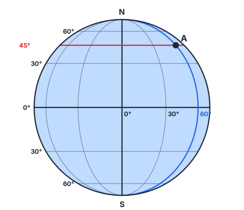
A point’s position on Earth is given by two numbers — latitude and longitude.
- Latitude is the arc of a meridian from the equator to the point, 0° to 90°, north (N) or south (S). It is read from parallels.
- Longitude is the arc of a parallel from the prime (Greenwich) meridian to the point, 0° to 180°, east (E) or west (W). It is read from meridians.
Along a meridian 1° ≈ 111 km; along a parallel 1° is ≈ 111 km at the equator, decreasing towards the poles and reaching 0 at the pole
Tashkent lies at about 41° N, 69° E. All meridians are the same length, while parallels get shorter from the equator towards the poles.
Worked example
Points A (45° N) and B (37° N) lie on the same meridian. How far apart are they?
- Both are in the same hemisphere, so subtract the latitudes: 45 − 37 = 8°.
- Distance: 8 · 111 ≈ 888 km.
- Answer: about 888 km. If the points are on opposite sides of the equator (say 10° N and 5° S), add the latitudes: 10 + 5 = 15°.
§3. Direction and azimuth
The azimuth is the angle measured clockwise from north to the direction of an object:
North 0°, north-east 45°, east 90°, south-east 135°, south 180°, south-west 225°, west 270°, north-west 315°
The back azimuth = azimuth ± 180° (keeping the result between 0° and 360°). If you set off on 60°, you return on 240°.
On the ground direction is found with a compass, whose magnetic needle points north. Without a compass you can still orient yourself: at noon in the Northern Hemisphere the Sun is in the south, and the Pole Star marks north.
§4. Showing relief; topographic maps
- Absolute height is measured from sea level; relative height from one point to another.
- Contour lines join points of equal absolute height. Closely spaced contours mean a steep slope; widely spaced ones a gentle slope. Slope ticks (short dashes) show which way the slope runs down.
- Small-scale maps show relief with layer colours: green for lowlands, yellow and brown for uplands and mountains, blue for depths.
Topographic maps have little distortion because they show small areas, where the Earth’s curvature hardly matters.
Worked example
A hilltop lies above the 230 m contour and its foot on the 130 m contour; the contour interval is 20 m. How many contours lie between foot and top, and roughly what is the relative height?
- Contours: 130, 150, 170, 190, 210, 230 m — six in all.
- Relative height: a little over 230 − 130 = 100 m (the top is above 230 m but below 250 m).
- Answer: six contours; relative height between 100 and 120 m.
§5. Measuring time
The Earth turns 360° in 24 hours → 15° per hour, 1° in 4 minutes.
Δtime = Δlongitude · 4 minutes
- Local time depends on a place’s meridian; it is later towards the east (the Sun rises earlier).
- Standard (zone) time: the Earth is divided into 24 time zones, each 15° wide, with the same time throughout a zone. Uzbekistan uses UTC+5.
- Near the 180° meridian runs the International Date Line: crossing it from west to east you put the date back one day; from east to west you move it forward one day.
Worked example
In Tashkent (69° E) the local time is 12:00. What is the local time in a city at 39° E?
- Longitude difference: 69 − 39 = 30°.
- Time difference: 30 · 4 = 120 minutes = 2 hours.
- The city is to the west, so its time is earlier: 12:00 − 2 h = 10:00. Answer: 10:00.
§6. Types of maps and projections
By content: general maps (relief, water, settlements, roads) and thematic maps (climate, soils, population, industry — physical and socio-economic maps). By area: maps of the world, continents, countries and regions. An atlas is a collection of maps made for one purpose.
A globe is the most accurate model of the Earth: shape, area, distance and angles are not distorted. A sphere cannot be flattened without distortion, so maps are drawn on map projections — cylindrical, conic or azimuthal. Each distorts area, angles or distance to some degree, and distortion grows towards the edges of the map.
Modern cartography relies on satellite images, GPS (satellite navigation) and GIS (geographic information systems); this is how online maps are made.
Check yourself
- Convert 1 : 500,000 into a verbal scale.
- 3 cm on a 1 : 4,000,000 map. Real distance?
- Distance between 20° N and 10° S on one meridian?
- The azimuth of south-west?
- At 69° E it is 15:00. Local time at 84° E?
- What is a slope with closely spaced contours like?
- Azimuth 110°. Back azimuth?
- 9 cm² on a 1 : 100,000 map. Real area?
Common mistakes
- Writing that longitude runs to 90° — it runs to 180°.
- Mixing up centimetres and kilometres when converting scale: 1 km = 100,000 cm.
- Subtracting latitudes on opposite sides of the equator — they are added.
- Getting the direction wrong in local-time problems: east is later, west is earlier.
- Forgetting to square the scale for area: if 1 cm is 2 km, then 1 cm² is 4 km².
Score: 0 / 8 correct (0 attempted)